Synspective released the First Image from its Small SAR Satellite "StriX-α"
TOKYO / AGILITYPR.NEWS / February 16, 2021 / Japanese Space Industry Startup
Synspective Released the First Image from its Small SAR Satellite "StriX-α"
Synspective Inc., a SAR satellite data and analytic- solution provider, announced its first success on the first image acquisition from its first own SAR satellite “StriX-α”. This is the first success in Japan that a commercial SAR satellite(100kg class) image has obtained from space.
"StriX-α" was launched by Rocket Lab's Electron, from New Zealand’s Mahia Peninsula launch site, on December 15th (JST) and put into the target orbit: at an altitude of 500 km in a Sun Synchronous Orbit (SSO). It has been successfully operated since and the very first imagery was successfully acquired on February 8th.
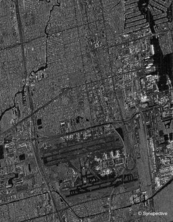
■ SAR images
Observation date and time:February 8th, 2021, around 12:00 (Japan time)
Observation location:South Florida, USA
■ Future SAR Satellite Constellation
The second demonstration satellite "StriX-β" is scheduled to be launched in 2021. It is aimed to demonstrate "InSAR (Interferometric SAR)" technology in orbit, a special SAR analytics technique to detect millimeter-level displacements on the ground surface.
Synspective aims to build a constellation of 6 satellites by 2023 and 30 satellites by the late 2020s. With the constellation of 30 satellites in low Earth orbit , it makes it possible to observe the location of disaster occurring anywhere in the world within the time of two hours (with 6 satellites, it is within 24 hours). Synspective is currently developing an automated process that analyzes the observed data, assesses (understand) the situation of the disastered place at the early stage, and provides a solution. By establishing its constellation, Synspective aims to contribute dramatical improvements in the world's disaster response efforts.
■Comment from Dr. Motoyuki Arai, founder and CEO at Synspective
“For a satellite data solution company, the most difficult but the most crucial milestone is the acquisition of data from an own-built satellite. Thanks to many years of hard work, including the ImPACT program, we have just obtained this great achievement. I would like to express our sincere gratitude to our team and am proud to move forward together.
Now, we are proceeding with preparations for data sales. As launching the "StriX-β" within this year, we are planning to release more solution services using our own data. We will ensure to continue producing results in order to create a more efficient and resilient world.”
■Comment from Toshihiro Obata, Board Director and General Manager of Satellite System Development Department
“We are very happy that all the efforts of our development team members achieved this successful early demonstration. We continue to give further efforts to improve the quality of image and provide solutions. With partners, we are currently setting up a secure line for our satellite serial productions, by introducing manufacturing and quality control technologies from the non-space industries. We appreciate your further interest in our progress.”
■ About StriX-α
- Development
Synspective applied the technology from Japanese Cabinet Office's program "ImPACT (Innovative Research and Development Promotion Program)" onto the development of its own small SAR satellite "StriX-α".
Synspective has successfully developed a small, lightweight, and highly compressed SAR system in collaboration with the Japan Aerospace Exploration Agency (JAXA) and the Hirokawa Laboratory of School of Engineering, Tokyo Institute of Technology. Development of the outer part of the satellite “bus” was done with Nakasuka and Funase Laboratory of the University of Tokyo. Keio University’s Shirasaka Laboratory made significant coordinations with various expected users.
This first image acquisition from our in-orbit demonstration was as a result of cooperation from these universities and JAXA’s "J-SPARC" program for utilization of small SAR technology.
- Size / performance
“StriX-α” is a small SAR satellite. Its weight is 100kg class, which is 1/10 of a conventional SAR satellite. The total cost of development and launch can be reduced to 1/20 by making the antenna retractable into 70 square centimeters when launching. Antenna will be deployed to 5 meters length in orbit. Data is observed with VV polarization and it can capture 10 to 30 kilometer width with the resolution of 1 to 3 meters on ground. Two observation modes are available: strip map and sliding spotlight mode.
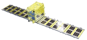
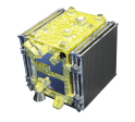
*Left: at launch, Right: in orbit,deployed configuration
- Name “Strix”
The name "StriX" is derived from the scientific name of the owl, "Strix uralensis". Owls and SAR satellites share several similarities. Just like owls can see in the darkness and are active at night, SAR satellites can observe at night or even through the clouds. StriX’s antenna also looks like an owl's flying wings. In western countries owls are sometimes used as a symbol of wisdom as Synspective’s mission is to create a world that can learn and progress. Imagine that StriXs flying in space hunting the world activities from a forest of information.
- About Synthetic Aperture Radar (SAR)
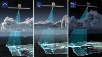
The SAR (Synthetic Aperture Radar) satellite sends microwaves to Earth to capture the shape of ground surface and buildings. In most regions in Asia, observation during long and frequent rainy seasons has been a challenge with optical satellites.
SAR can achieve stable observations independent of time of day/night or weather conditions.
- SAR Satellite data for business use
One of the applications of SAR satellite data is natural disaster monitoring. In the case of a typhoon, SAR data can determine submerged areas, blocked roads by flooding, and the total damaged regions.
Another use case in business applications is for infrastructure and urban development by using its wide data coverage. Topographic or land use information can help to make decisions at the planning stage of these developments. At the construction stage, it can be used to monitor the progress of construction and the material status at the site.
Satellites can monitor numbers of construction sites all over the world in time series and keep detecting surface changes after the completion of construction. For example, it can detect the early stage of unexpected pressure from a dam that has been changing its land shape, or distortion of larger structures such as harbors and runways.
Synspective has already released several services derived from SAR data. As a disaster response, the "Flood Damage Assessment" solution assesses inundation damage (inundated area and its depth, damaged roads, and damaged buildings). The "Land Displacement Monitoring" solution detects millimeters level of fluctuations on the ground surface over a wide area. These solutions are being already successfully used by many customers.
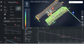
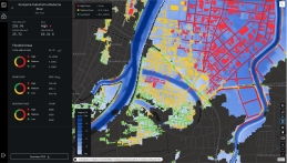
*Left:「Flood Damage Assessment」*Right:「Land Displacement Monitoring」
By incorporating its own SAR data into these services, Synspective will become the only company in the world that can handle all the process from developing its own satellite to providing solutions.
Synspective believes that combination of various data (IoT data, PoS data, GPS, thermal sensors, etc.) with analytic information from SAR images can support important decision- making.
For inquiries regarding our solution services:hello-sol@synspective.com
About Us
■About Synspective
Synspective provides one-stop-solutions using geospatial data from its own SAR satellites, upon its mission to create a progressive world based on real data. The core technology was developed by the ImPACT program led by The Cabinet Office, Government of Japan. Synspective is building a constellation of its own small SAR satellites and to provide its data and analytic information to governments and commercial outfits.
Contacts
Links